For centuries, the village was a patchwork of arable and pasture fields of various shapes and sizes. Following the enclosures and with modern farming practices, many of the ‘farm fields’ became much larger and absorbed some of the ‘old fields’.
Further, over time and with the demands for housing, many fields have been developed.
One such field was ‘Dunhams’. At the turn of the 19th century, the field comprised 3 acres, 3 roods and 36 perches (3a 3r 36p). By the mid-Victorian period, a house had been erected on the land. By 1921, this house was referred to as ‘Wayside’.
‘Dunhams’
In 1800, William Kiddle owned ‘Dunhams’. He also owned and lived in a house in Church Street (Islay House now Orchard Cottage).
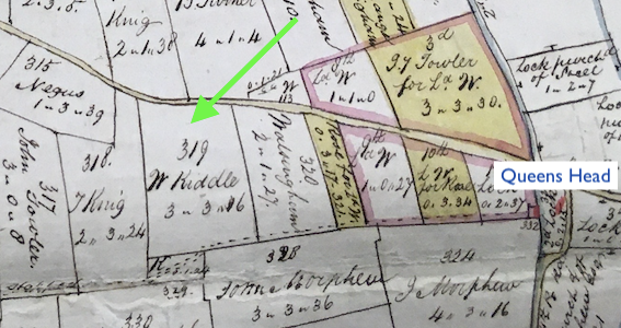
‘Dunhams’ adjoined the road from the village to Attleborough.

Extract from 1802 Map of Great Ellingham. Russell James Colman Plans. Norfolk Record Office Cat. Ref. C/Ca 1/84
All rights reserved Norfolk Record Office. With kind permission of NRO
The green arrow on the above extract from the Great Ellingham Inclosure Map 1802, shows the field known as ‘Dunhams’.
By 1819, William Kiddle had died and the ownership ‘Dunhams’ and Kiddle’s other property, passed to his daughter and son-in-law, Jane and Thomas Warren. ‘Dunhams’ now comprised two parcels of land: one piece pasture and the other arable.
The Great Ellingham Tithe Map of 1843 together with the associated schedules, tells us that Thomas Warren still owned ‘Dunhams’ in the 1840s. However, the land was ‘occupied’ by William Downes. Downes also occupied Warren’s house in Church Street (formerly owned by William Kiddle).
In 1845, Warren’s house in Church Street was sold at auction. It follows that ‘Dunhams’ also changed ownership. Henry Pettitt purchased the Church Street house. However, I do not believe he purchased ‘Dunhams’.
Nonetheless, a house was then built on the arable part of ‘Dunhams’.
Given that the house appears on the First Edition of the Ordnance Survey Map (six-inch to the mile) dated 1879-1886, we can be confident that the house was built between 1843 and 1886.

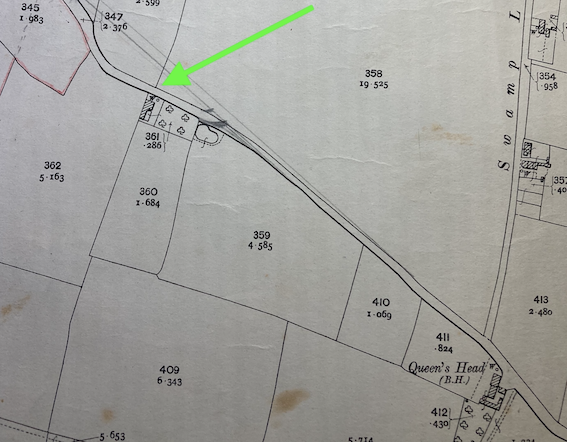
Extract from 1906 Ordnance Survey Map. Second Edition. Surveyed in 1881. Revised 1904.
The green arrow on the above extract from an 1906 O.S. Map shows the position of ‘Wayside’. Decades later, the road to Attleborough was ‘straightened’. The pencil lines show the route of the present-day road to Attleborough, leaving a ‘lay-by’ in front of ‘Wayside’.
Owners & Occupiers
Without sight of historical deeds, it can be difficult to establish who lived in this house.
Census returns will provide details of a particular family or household in a street. However, the census enumerator did not always visit consecutive households. Accordingly, we cannot assume that the list of households concurs with the position of the households in the street. Further, it was not until the 20th century, that we routinely see house numbers and names on census returns and electoral registers.
1921
The census of 1921 shows William and Mary Kettle living at ‘Wayside’, Attleborough Road. The history of ‘Wayside’ continues with the article ‘Wayside’ at the first half of the 20th Century.

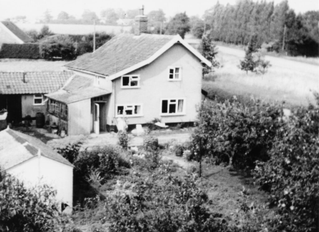
‘Wayside’, Attleborough Road. 1970. Courtesy Jane Brand
Sources:
1921 census RG15. Registration District 231. Great Ellingham Schedule 7. Viewed via www.findmypast.co.uk
1802 Russell James Colman Plans. Great Ellingham. Norfolk Record Office. Catalogue Ref. C/Ca 1/84.
1799-1842 F W Horner, Records of the Surveyors to Commissioners for Inclosure in Parishes in Norfolk and Suffolk. Great Ellingham (Act 1799). Norfolk Record Office. Catalogue Ref: NRO, BR 90/2
1800 Inclosure Commissioner’s Particulars and Valuation, Great Ellingham. Norfolk Record Office. Catalogue Ref: NRO, MC 2213/119
Great Ellingham Tithe Map 1843. Tithe Apportionments, 1836-1929 [database online]. TheGenealogist.co.uk 2023. Original data: “IR29 Tithe Commission and successors: Tithe Apportionments” The National Archives