In the informative booklet “A Little History of Great Ellingham“, the author, Mr William Robert Lebbell (1885-1965), mentions that (in the 1960s) the ‘Poor’s Firing Land’ was the only link from the time of the Great Ellingham Inclosures (c.1800) with modern Great Ellingham.
Mr Lebbell describes the pieces of land as being untended and in four lots, with a total acreage of 51 acres, “and was the only land owned by the village and the community since the enclosure“.
The poor of the village were allowed to remove any firewood they could gather from the land. Later, some or all of the land was let to tenants. The Overseers for the Poor would use the income from the rent to make payments for ‘firing’ to those villagers in need. A stock of coal was also purchased to distribute amongst the poor.
Ten acres of the Poors Firing Land were to the west of the southern part of Long Street, and Mr Lebbell describes this land as “the last remaining ‘common’ of gorse, grass and brambles, and was inhabited by vipers up until the second World War“.
Where were the parcels of Poor’s Firing Land?
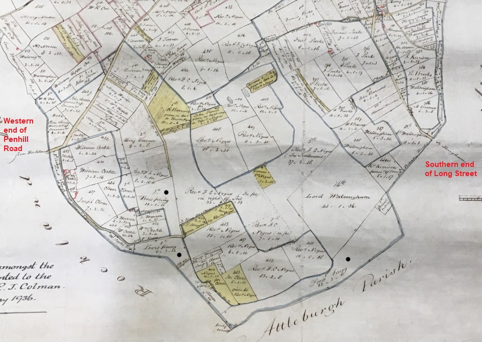
Extract from 1802 Map of Great Ellingham. Original held at Norfolk Record Office. Russell James Colman Plans. Cat. Ref. C/Ca 1/84. With kind permission of NRO
A Particulars and Valuation for the Parish of Great Ellingham in relation to the Inclosures c.1800, lists the following allotments as being the Poor’s Firing:
- Broad Common comprising 32a 3r 8p
- Pennell Common 6a 3r 12p
- Pennell Common 10a 1r 10p
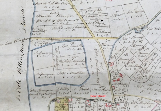
- Stalland Common 2a 2r 2p
The black dots on the above extract from an 1802 map of Great Ellingham (which also relates to the inclosures) shows the position of the allotments on Broad Common and Pennell Common.
Extract from 1802 Map of Great Ellingham. Original held at Norfolk Record Office. Russell James Colman Plans. Cat. Ref. C/Ca 1/84. With kind permission of NRO
The black dot on this extract from the same 1802 map shows the position of the Poor’s Firing Allotment on Stalland Common.
Tenants
A survey of Great Ellingham undertaken 1817-1819, lists Thomas Warren as occupying the Poor’s Firing Allotment (2a 2r 2p) on Stalland Common. This piece of land was later let to Robert Twidney.
The allotment on Pennell Common comprising 10a 1r 10p was at that time divided into two parcels of land. These parcels of land were both let to John Turner. Reuben Haythorpe, Edward Wilkins and Robert Wilkins each later rented some of this land.
Further pieces of the Poor’s Land on Pennell Common and the allotment on Broad Common, were again divided into smaller parcels of land, and let to Robert Barnard and Thomas Kerrison. Some of this land was later let to Robert Grice.
Fuel Allotment Charity
The Town Accounts for the year 1804 show that the Overseers of the Poor made allowances towards firing to the following villagers:
- Henry Halls the sum of 15s
- Robert Lait 3s 9d
- Henry Barrett 5s
- Edward Fox 3s
The Overseers also used the income from the ‘Poors Firing Land’ to buy fuel for the poor, particularly during the winter months. Upstanding members of the community (usually the Overseers for the Poor, or the Churchwardens) would organise a delivery of coal to the ‘Coal House‘. The fuel was then distributed amongst those in need.
Much later in 1874, a scheme was incorporated for the Fuel Allotment Charity for Great Ellingham.
Sources:
Lebbell W R & Fay S. ‘A Little History of Great Ellingham‘. Date unknown.
1802 Russell James Colman Plans. Great Ellingham. Norfolk Record Office. Catalogue Ref. NRO, C/Ca 1/84.
1799-1842 F W Horner, Records of the Surveyors to Commissioners for Inclosure in Parishes in Norfolk and Suffolk. Great Ellingham (Act 1799). Norfolk Record Office. Catalogue Ref: NRO, BR 90/2
1800 Inclosure Commissioner’s Particulars and Valuation, Great Ellingham. Norfolk Record Office. Catalogue Ref: NRO, MC 2213/119
Great Ellingham Parish Chest. Town Accounts 1804-1819. Norfolk Record Office.PD 609/39. Also available via www.familysearch.org

