Before the Great Ellingham Inclosure Act of 1799, there were several paths threading their way through the village. No doubt many of these footways were in constant use by the villagers to get from one part of the village to another, or to travel to the adjacent villages or towns. Some of these ancient paths exist today. However, at least fourteen footways disappeared following the Inclosure Act.
In addition to showing the various inclosures of land, an 1802 map of Great Ellingham reveals the routes of the private and public roads. The position of most of these roads, with minor variations, will be familiar to us today. The map also shows the routes of the fourteen footpaths which were ‘put by and discontinued‘ by the Commissioners appointed by the 1799 Act.

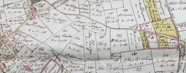
Extract from 1802 Map of Great Ellingham. Original held at Norfolk Record Office. Russell James Colman Plans.
Cat. Ref. C/Ca 1/84. With kind permission of NRO
The above extract from the 1802 Map of Great Ellingham shows the road leading from Attleborough to Great Ellingham (right to left beginning half way up the page).
The Norfolk Record Office holds an original document prepared by the Commissioners appointed by the Inclosures Act 1799, giving notice of the stopping up of the fourteen footpaths. The document lists each pathway with details of the route, including reference to the various parcels of land through which the footpaths proceeded.

Extract from 1802 Map of Great Ellingham. Original held at Norfolk Record Office. Russell James Colman Plans. Cat. Ref. C/Ca 1/84. With kind permission of NRO.
The ‘Seventh’ footpath (as described by the Commissioners in the Notice c.1799), is shown by the dotted line running horizontally from right to left on the above further extract from the 1802 Map.
The Commissioner’s Notice describes the ‘Seventh’ footpath as:
“One other footway beginning at the Cottages of Jonathan Lock against the Burying Ground Common, and proceeding through Dove house field, Middletons Pightle belonging to James Rose, Dove house Pightle belonging to Lord Walsingham, Calvers Pightle and Clay Pit Close belonging to Thomas King, the Three Acres, Three Corner Piece, and Upper Tan Yard Piece belonging to John Towler and the Four and Half Acres belonging to Mr Negus to the Street”
‘The Cottages of Jonathan Lock’ were dwellings near to another cottage also owned by Jonathan Lock. This cottage was later known as the Queen’s Head Public House.
We can follow the route of the footpath running along the edge of the three allotments on ‘Dovehouse field’, through the various fields before coming out on the road which today we know as Church Street. In 1802, that part of Church Street (near Mill Farm) where the 7th footway finished, was known as ‘the Street’. At that time ‘the Street’ also included the northern end of Long Street.
The above map also shows that the ‘9th footway” (also discontinued by the 1799 Act) joined the “7th footway” in Upper Tan Yard Piece (shown numbered 312) belonging to John Towler.
Sources:
1800 Inclosure Commissioner’s Particulars and Valuation. Great Ellingham. Norfolk Record Office MC2213/119
F.W. Horner, Records of the Surveyors to Commissioners for Inclosure in Parishes in Norfolk & Suffolk. 1799-1842. Great Ellingham (Act 1799). Norfolk Record Office. Catalogue Ref BR 90/2
1802 Map of Great Ellingham. Russell James Colman Plans. Norfolk Record Office. Catalogue Ref. C/Ca 1/84
nd [19th century]. Inclosure Award extract. Great Ellingham regarding footpaths etc. Catalogue Ref: MC 2213/123