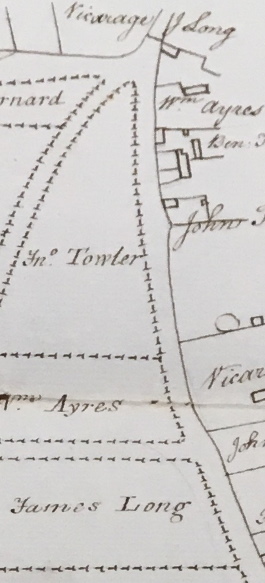
Extract from 18th Century Map. Town Green, Hyrne and Broad Commons in Great Ellingham held at Norfolk Record Office. Cat. Ref. MC2213/113, 941X7. With kind permission of NRO.
The above extract from an 18th century map of Great Ellingham shows the position of the two parcels of land owned by James Long (at the top and bottom of the map).
The Statement of Claims c.1800 relating to the Great Ellingham Inclosures, includes a claim by James Long of: One cottage and one acre of land occupied by himself. All freehold. James Long also claimed certain rights over the commons and waste lands in Great Ellingham benefiting his property.
Where was James Long’s Cottage?
The Commissioners’ Particulars and Valuation for Great Ellingham of 1800, reveal that James Long owned and occupied:
- No.301 Cottage and Garden 0A 0R 5P
- No. 302 A Garden 0A 2R 12P
- Allotment on Town Green 1A 3R 26P

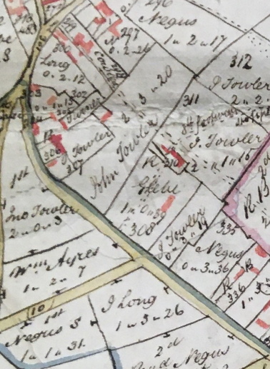
Extract from 1802 Map of Great Ellingham. Original held at Norfolk Record Office. Russell James Colman Plans. Cat. Ref. C/Ca 1/84. With kind permission of NRO
The numbering used on the 1802 Map of Great Ellingham (above), corresponds with the numbering of the various parcels of land detailed in the Commissioners’ Particulars and Valuation of 1800. This enables us to identify the position of James Long’s property.
James Long’s allotment on Town Green is clearly visible towards the bottom of the map, lying at the junction of Long Street and Town Green. By around 1840, a dwelling had been built on this land.
The Garden numbered 302, and measuring 2 roods and 12 perches (0.2.12), can be seen at the top of the map. The parcel of land comprising 5 perches consisting of the cottage and garden, is not so easily identifiable on the map. However, the number ‘301’ seems to have been written in the road adjacent to the parcel of land numbered ‘302’. Given that the red colouring on the map shows the approximate position of buildings, it is likely that James Long’s cottage with garden lies very close to the road and to the ‘Garden’ as numbered 302.
Today, the Post Office & Village Shop lies within what was once James Long’s large garden (numbered 302 of the 1802 map).
James Long
The Great Ellingham Parish Registers reveal a baptism for a James Long, son of James and Mary Long, on March 29th, 1761. The Parish Registers also show a burial for a James Long (married man) on December 26th, 1810.
However, without any further information, I cannot be certain whether one or both of these entries relate to the James Long who, in the early 1800s, lived in a cottage just into Long Street (near to the junction with Church Street and Chequers Lane).
Updated September, 2020
Sources:
Great Ellingham Parish Registers Norfolk Record Office PD/609. Also available at FamilySearch.org https://www.familysearch.org/search/image/index?owc=4J8C-CB7%3A29627201%3Fcc%3D1416598
18th century Map Pennell and Anchor Commons in Great Ellingham held at Norfolk Record Office catalogue reference MC 2213/114, 941X7
1800 Inclosure Commissioner’s Particulars and Valuation – Great Ellingham – held at Norfolk Record Office catalogue reference MC 2213/119, 941X7
1802 Map of Great Ellingham. Russell James Colman Plans. Original held at Norfolk Record Office. Cat. Ref. C/Ca 1/84.