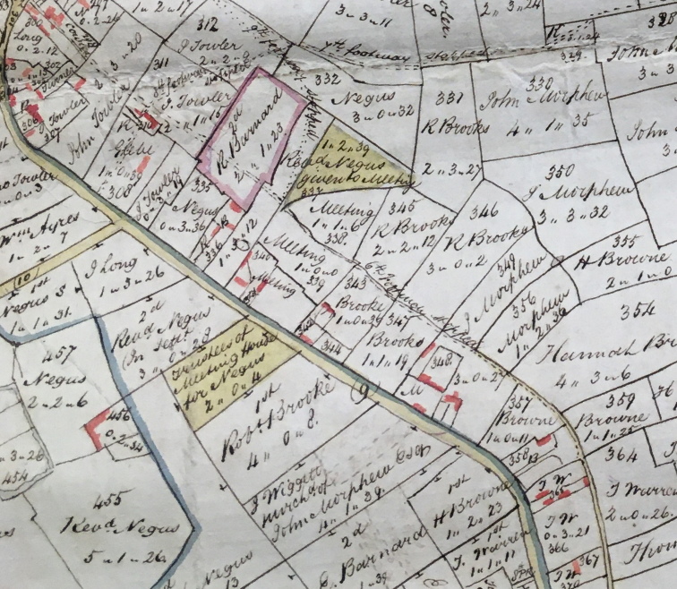
The Inclosures Map for Great Ellingham of 1802 shows four connecting footways weaving their way through various inclosures of land between Long Street and the road leading to the town of Attleborough.
However, these four footpaths (together with ten others), were ‘put by and discontinued ‘ by the Inclosure (Great Ellingham) Act of 1799.

Extract from 1802 Map of Great Ellingham. Original held at Norfolk Record Office. Russell James Colman Plans.
Cat. Ref. C/Ca 1/84. With kind permission of NRO
Sixth Footway
One such footpath was the ‘Sixth Footway’.
The above extract from the 1802 shows the dotted line indicating the route of the ‘Sixth’ footway (and marked ‘6th footway stopped‘). The path begins at ‘the Street’ (now part of Church Street) and ended at a point at the southern end of Long Street.
Notice
A Notice of the intention to discontinue the pathways pursuant to the directions of the Act of Parliament for the Great Ellingham Inclosure 1799, was signed by Meadows Taylor, Solicitor, ‘by order of the Commissioners‘.
The Notice described the ‘Sixth‘ footway as:
One other footway called Church Path beginning at the Street and proceeding through the yard and Homestall belonging to Elizabeth Cowles, Pitts Close belonging to John Towler, Yeomans belonging to Mr Negus and Robert Barnard respectively, Whalebelly belonging to the said Mr Negus, the Heart Piece belonging to the Trustees of the Meeting House, the Homestalls belonging to Robert Brooke, Hannah Browne, Thomas Warren, and Henry Mason respectively to the Green Way
Route
Given that the numbering of the inclosures on the 1802 map corresponds with the numbering used in a Particulars and Valuation of Great Ellingham, (undertaken in 1800 by the Commissioners for the Great Ellingham Inclosures), it is possible to follow the route of the pathway through the various parcels of land.
Starting Point near to Elizabeth Cowles’ Land
The starting point of the Sixth footway in the Street was near to land owned by Elizabeth Cowles and where the Tower Brick Mill was built some 40 years after the footpath was discontinued.
Elizabeth Cowles owned two properties. A cottage, barn and yard which she occupied herself, and a house, baking office, yard and garden which was occupied by Henry Neale (later by Benjamin Buck).
Through John Towler’s Land
The next inclosure was Pitts Close owned by John Towler. A barn and a shed stood on this land. The footway proceeded through the next inclosure (numbered 311 on the map) which was known as Tan Yard Piece. This land was also owned by John Towler.
A further discontinued footway (referred to on the 1802 map and the Commissioner’s Notice as the 8th footway) crossed the 6th footway in Tan Yard Piece. The 8th footway began in Long Street before proceeding through Tythe Barn Yard (numbered 308 on the 1802 map) and then through the grounds of the Tan Office and yard of Thomas King (owned by John Towler).
Robert Barnard’s Land
Picking up the 6th footway again, after Tan Yard Piece, the footway continued through Robert Barnard’s allotment. Known as ‘Yeomans’, this allotment comprising two acres, one rood and twenty three perches (2a 1r 23p) is edged pink on the above extract of the 1802 map.
Reverend F C Negus
The 9th footway (also discontinued by the Act of 1799), branches out from the 6th footpath in the next inclosure called ‘Whalebellys’ (or Whalebelly). This inclosure was occupied by Robert Barnard. However, it was owned by the Reverend F C Negus.
Meeting House Trustees
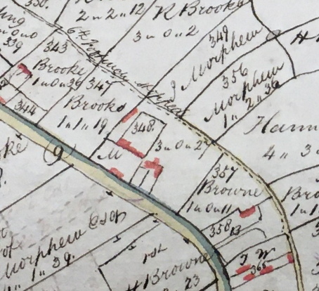
Clipping the corner of another part of ‘Whalebelly’ (inclosure numbered 337 on the map) which was then in the ownership of the Trustees of the Meeting House (the Baptist Church), the 6th footpath continued through Heart Piece (also belonging to the Trustees of the Meeting House), before proceeding through various Homestalls.

Extract from 1802 Map of Great Ellingham. Original held at Norfolk Record Office. Russell James Colman Plans. Cat. Ref. C/Ca 1/84. With kind permission of NRO
We can see the various Homestalls (with the numbering) through which the 6th footway passed through on the further extract from the same 1802 Map.
Brooke, Wiggett & Thurston
The Particulars and Valuation of 1800 (which I mentioned earlier), describes inclosure numbered 343 as a piece of land adjoining the House, Outbuildings, Barn, Stable, Yard and Garden (numbered 342) owned by Robert Brooke but occupied by George Caddy.
Proceeding through a further inclosure owned by Robert Brooke (numbered 347 and known as ‘Piece against Hurstons’), the 6th pathway continued through a Homestall comprising 3a 0r 27p (349) which, according to the Particulars and Valuation of 1800, was then owned by John Wiggett but let to John Thurston (as was the adjacent House, Outbuildings, Barn, Stables, Yard and Garden at number 348).
Hannah Browne
The pathway progressed along the edge of an Orchard belonging to Hannah Browne (No.357). It continued through the rear of the grounds of Hannah Browne’s House, Outbuildings, Barn, Stables, Yard and Garden.
Concludes at ‘the Green Way’
I have mentioned that the Notice by the Commissioners under the Inclosures Act 1799 (for the stopping up of the fourteen footpaths), mentions that the Sixth footway concludes at ‘the Green Way’ belonging to Henry Mason.
At first glance, the 1802 Map suggests that the route finishes in Hannah Browne’s land i.e. the dotted line comes to an end. However, the dotted line continues into a recognisable pathway (brown shaded line).
Looking for a mention of ‘Green Way’ in the Particulars & Valuation of 1800, the parcel of land numbered 373 (in the Particulars and Valuation) is ‘Green Way Piece’ comprising two acres one rood and one perch (2a 1r 1p) owned and occupied by Johh Wiggett (formerly owned by ‘Mason’). The 1802 Map clearly shows the owner as Henry Mason.

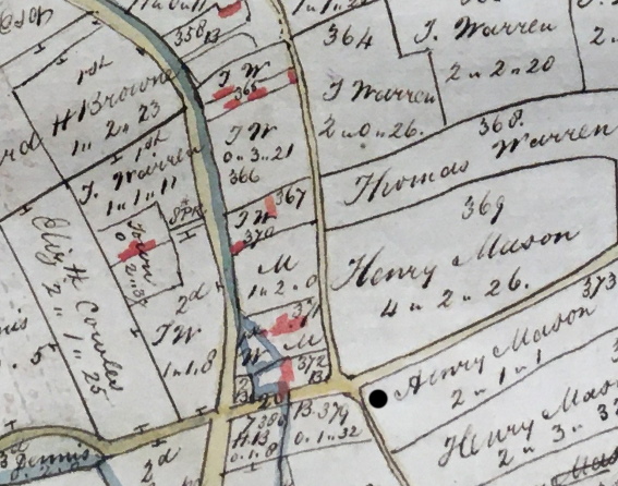
Extract from 1802 Map of Great Ellingham. Original held at Norfolk Record Office. Russell James Colman Plans. Cat. Ref. C/Ca 1/84. With kind permission of NRO
The black dot indicates the position of ‘Green Way Piece’ (numbered 373). Therefore, the Sixth footway concluded at the junction with Shruggs Lane.
Continues through Thomas Warren’s Land
Accordingly, the route of the Sixth footway continued on from the lands of Hannah Browne (at the top of the above extract from the 1802 map), proceeding through lands of Thomas Warren.
The Particulars and Valuation of 1800 describes the parcel of land numbered 364 as ‘Two Acres’, 365 as ‘House, Barn, Stable, Yard and Garden’ and No. 366 ‘Homestall’. These were occupied by Thomas Warren.
Concludes in Henry Mason’s Land
The footway finally concludes in Henry Mason’s land. The 1800 Particulars and Valuation suggest that John Wiggett purchased from Henry Mason. The 1800 document also shows that the ‘House, Outbuildings, Barn, Stable, Yard, Garden and Hempland’ numbered 371 on the 1802 map, was then occupied by John Wiggett. This property is what we today know as White House Farm.
The ‘Cottage, Garden and Hempland’ numbered 372 on the map was owned by Hannah Browne. However, it was occupied by Edward Houchen.
Sources:
1800 Inclosure Commissioner’s Particulars and Valuation. Great Ellingham. Norfolk Record Office MC2213/119
F.W. Horner, Records of the Surveyors to Commissioners for Inclosure in Parishes in Norfolk & Suffolk. 1799-1842. Great Ellingham (Act 1799). Norfolk Record Office. Catalogue Ref BR 90/2
1802 Map of Great Ellingham. Russell James Colman Plans. Norfolk Record Office. Catalogue Ref. C/Ca 1/84
nd [19th century]. Inclosure Award extract. Great Ellingham regarding footpaths etc. Catalogue Ref: MC 2213/123