I was idly searching the 1921 census online when I came across an entry for the ‘Red House’ in Long Street. I also discovered that in 1921 the property was occupied by Francis King Mills, Jane Mills and Mary Annie Mills.
Where in Long Street is the Red House – and does it still stand today?
I also wanted to know more about the Mills family – were they local, what did they do and how long did they stay in the house?
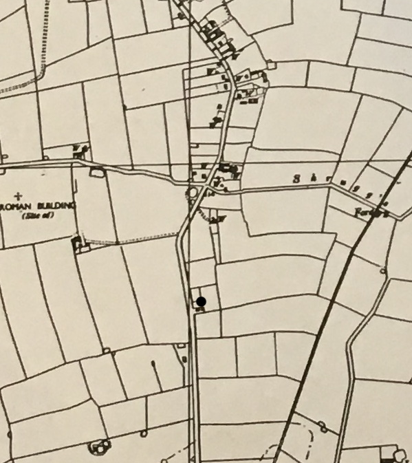
Where is Red House?

Extract from O.S. Map c.1945. Courtesy of Ray & Maureen Beales
Red House still exists today, and is located on the eastern side at the southern end of Long Street. The black dot on the above extract from a 1945 map of Great Ellingham shows the location of Red House. Although named Red House, the house is not red – but perhaps it was in earlier times.
When was it Built?
A house (or any kind of building) does not show on the Great Ellingham Tithe Map (c.1844). However, the house (or, at least, a house) is shown on the First Ordnance Survey Map (Norfolk 1879-1886). Accordingly, the house was likely built sometime between the drawing up of the Tithe Map and the First Ordnance Survey Map.
What we do not know is whether the house standing today (or any part) is the original house. The house would have undergone many changes over the last 160 years or so, including its name. During the latter part of the 19th century, the house was called ‘Hill Cottage’.


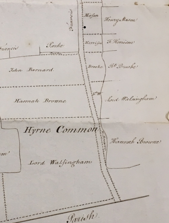
Allotment on Hyrne Common
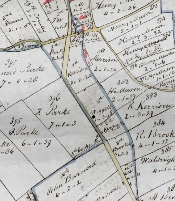
The black dot on the above extract from an 18th century map (left) and on the extract of a map from 1802 (right), shows the approximate location of where Hill Cottage (later Red House) was subsequently built.
We know from the two maps (and other documents from the Great Ellingham Inclosures) that the parcel of land on which the house was built was once an ‘Allotment on Hyrne Common’ which comprised 1a 3r 18p.
In the late 1700s, this land was owned by Henry Mason. By 1802, it was owned by John Wiggett. Mason (and subsequently Wiggett) owned a nearby farm, which later became known as White House Farm.
Incidentally, the blue lines on the 1802 map (on the right) show the boundaries of the common.
Francis & Jane Mills
Francis King Mills and his wife Jane came to Great Ellingham between the census of 1911 and the head-count of 1921. It appears that Mary Annie Mills (born c.1854 in Marham) is also living at Red House in 1921.
The 1911 census captures 55 year old bricklayer Francis Mills and his 63 year old wife Jane living in White Horse Street, Shropham. The couple had completed 20 years of marriage. They had no children. The census also tells us that Francis Mills was born in Wretton (a village approximately 6 miles from Downham Market) and Jane in Lakenheath, Suffolk.
Francis Mills died at the age of 70 in Great Ellingham. He was buried in the churchyard at St James on December 5th, 1923.
Just six months later, 78 year old widow Jane Mills died. She was buried in the same churchyard on the 3rd June, 1924.
The Jacksons
The next occupiers of the Red House were Walter and May Jackson (née Harper).
Walter Jackson
Born in Bunwell on the 30th June, 1899, Walter John M Jackson was the son of farmer Walter John Jackson and his wife Katherine Louisa. The 1911 census finds 11 year old Walter Jackson with his parents and siblings in Bunwell.
May Harper
May Harper was born on the 11 May 1901 in Norwich. The 1911 census captures 9 year old May with her parents, William and Susannah Harper, and her siblings at Tanyard Farm, Great Ellingham.
In 1913, May’s brother William C Jackson married Eva Kate Jackson who lived at nearby Fir Tree Farm.
Walter & May Jackson
The Electoral Registers for 1925 and 1928 lists Walter J Jackson in Long Street, Great Ellingham. I have no doubt Walter and May Jackson were at the Red House. However, the Electoral Registers of 1929 and 1931 do show the couple to be at the Red House, Long Street.
Move to Besthorpe
By 1939, Walter and May Jackson with their son, Walter, moved from Great Ellingham to Besthorpe.
Accordingly, the Red House would have new occupiers.
Sources:
18th Century Map. Town Green, Hyrne and Broad Commons in Great Ellingham. Norfolk Record Office. Cat. Ref. MC2213/113, 941X7
1802 Map of Great Ellingham. Norfolk Record Office. Russell James Colman Plans. Cat. Ref. C/Ca 1/84
1799-1842 F W Horner, Records of the Surveyors to Commissioners for Inclosure in Parishes in Norfolk and Suffolk. Great Ellingham (Act 1799). Norfolk Record Office. Catalogue Ref: NRO, BR 90/2
1800 Inclosure Commissioner’s Particulars and Valuation, Great Ellingham. Norfolk Record Office. Catalogue Ref: NRO, MC 2213/119
Norfolk County Council. Historic Map Explorer. http://www.historic-maps.norfolk.gov.uk
1911 census RG14/11494/14, RG14/11473/1
1901 census RG13/1542/16
Great Ellingham Parish Registers. Norfolk Record Office. PD 609.
1939 England & Wales Register. The National Archives; Kew, London, England; 1939 Register; Reference: Rg 101/6590g. Viewed via www.ancestry.co.uk
GRO Index. Free BMD website. 1913 Jun Qtr. Wayland District. Marriage Jackson, Eva K & Harper, William C. https://www.freebmd.org.uk/cgi/information.pl?cite=EszfYFfML5ZAIneenzoZMA&scan=1
1925, Spring Register. Southern Parliamentary Division of the County of Norfolk. Parish of Great Ellingham.
1928, Register of Electors. Southern Parliamentary Division of the County of Norfolk. Polling District of Ellingham, Great.
1929, Register of Electors. Southern Parliamentary Division of the County of Norfolk. Polling District of Ellingham, Great.
1931, Register of Electors. Southern Parliamentary Division of the County of Norfolk. Polling District of Ellingham, Great.